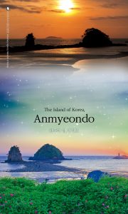
 Anmyeondo is an island off Korea’s west coast. With a total area of 113.46㎢, it is the sixth largest island in Korea.
Anmyeondo was originally a cape. Historically, the west coast of Korea served as a sea route to deliver grain, which was collected as tax from the provinces of Chungcheongdo, Jeollado, and Gyeongsangdo. Due to strong wind and waves, ship sinking accidents were frequent. In 1638, the government of Joseon built a canal to create a safe sea route by cutting out the land between Changgi-ri in Anmyeon-eup and Sinon-ri in Nam-myeon. After its transition from a cape to an island, it gained its name Anmyeondo Island. Anmyeondo was re-connected with the mainland with the construction of the Anmyeon Bridge in 1970.
Anmyeondo is part of the Taean Coastal National Park. Along its coastline, there are more than a dozen scenic beaches, including Bangpo, Ggotji, and Sambong beaches. Beaches on Anmyeondo are known for wide sandy beaches, gentle slopes, and clear water, attracting many summer vacationers. It is also famous for its recreational forest. The Anmyeondo Recreational Forest is the only area where Korea’s native red pine trees grow in clusters across 1.75㎢. The government of Joseon gave the red pine trees on Anmyeondo the name Anmyeonsong and restricted their usage only for building palaces, military vessels, and official purposes.
Like its name Anmyeon, meaning ‘sleeping comfortably’, Anmyeondo is an island of relaxation with beautiful beaches and lush pine tree forest.